Vancouver, British Columbia--(Newsfile Corp. - August 10, 2021) - Tower Resources Ltd. (TSXV: TWR) ("Tower" or the "Company") is pleased to report that a recently completed till sampling program on the Company's Rabbit North Property near Kamloops, British Columbia, has identified a strong gold grain anomaly indicating proximity to a new, hidden, alkalic porphyry Cu-Au deposit much more substantial than the known, exposed Cu-Au zones on the property.
The till heavy indicator mineral survey totaled 137 samples. Of these, 84 were collected at the southeast corner of the northern lobe of the G-shaped, 16,400 hectare property (inset map on Fig. 1), over or proximal to the 3-km-wide Durand alkalic stock (Fig. 1) which has been the focus of all previous exploration on the property. The remaining 53 samples were collected 5 to 8 km to the south on the small, unexplored southern lobe of the property (Fig. 2). The samples were collected 250 m apart on traverses spaced 1 to 2 km apart and oriented northeast-southwest to squarely cross the southeast direction of glacial ice flow and gold grain transport.
Feature Anomaly
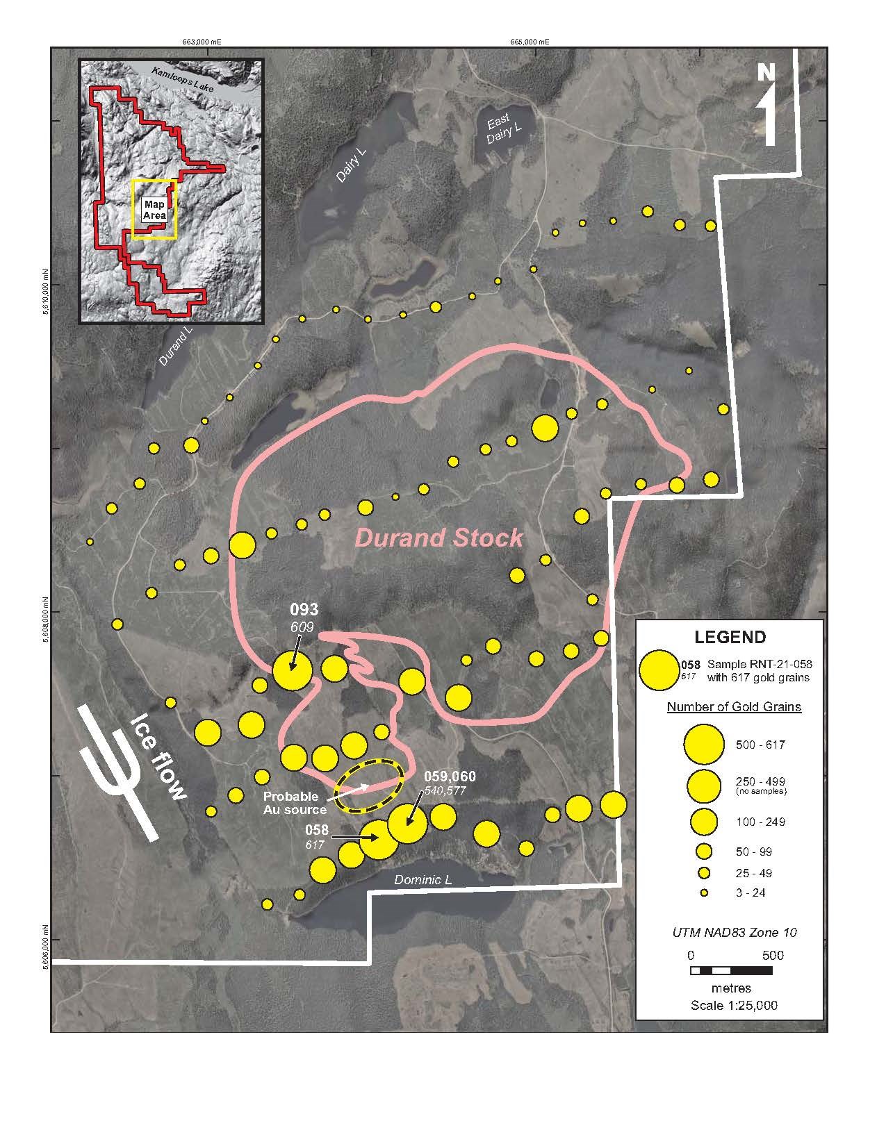
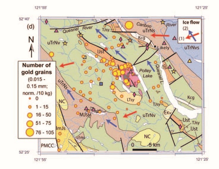
The heavy mineral concentrates from two contiguous samples, Nos. 058 and 059 (duplicated by QA/QC Sample 060) collected 250 m apart on a traverse 700 m directly down-ice from the Durand Stock, each contained approximately 600 gold grains (Fig. 1). Such a strong response is exceptional for a porphyry Cu-Au deposit due to the relatively low grades of most of these deposits. For example, the peak response obtained from a very similar till survey performed by the federal and provincial governments at the Mount Polley open pit mine (past production of 118.8 million tonnes at 0.227% Cu and 0.277 g/t Au) was only 105 grains (Fig. 3).
Stuart Averill, P.Geo., a Director of the Company, emphasized the importance to Tower of the strong gold grain anomaly:
"The Durand Stock has long been of exploration interest due to its similarity to the nearby intrusion that hosts New Afton's underground Cu-Au mine. Surface prospecting of the exposed areas of the stock has identified numerous Cu-Au occurrences but no economic deposits. This has led to the perception that the main remaining potential is for deep, New Afton-type deposits but these deposits are difficult to find and need a much higher grade to be economic.
Much of the stock and surrounding area is concealed by glacial till and has never been swept for large, shallow, subcropping, open-pittable Cu-Au deposits. Our goal at Rabbit North is to quickly and confidently identify the areas with the highest potential for these deposits. The indicator mineral sampling method that we are employing can be counted on to yield large, crisp gold grain anomalies near any significant, till-covered Cu-Au zones. It is also cost effective at the large scale of the property because only three to four samples are required per square kilometre."
Joe Dhami, President, added:
"Our recent flow-through financing has allowed us to resume exploration for porphyry copper-gold deposits at Rabbit North while continuing to aggressively drill the emerging gold-silver discoveries on our Nechako property. We are excited to be back at Rabbit North and to be rewarded so quickly with a prime new porphyry target."
A similarly strong, 609-grain gold anomaly was obtained from Sample 093 at the Chrysocolla Main zone, one of nine small Cu-Au occurrences (Fig. 4) that were previously identified by prospecting on the exposed parts of the Durand Stock. However, the number of gold grains in this sample is inflated because the sample site was directly over mineralized bedrock as evidenced by the still-pristine condition of most of the gold grains. In contrast, the broad gold anomaly in Samples 058 and 059 includes subequal populations of pristine and partially deformed grains indicating that the grains have undergone significant, dilutive glacial transport. The most probable location of the gold source is 200 to 500 m up-ice (northwest) beneath a 600-m-wide, till-covered gap between the exposed Buff and Dominic Cu-Au occurrences (Figs. 1, 4). No previous drilling has been done in this area.
Based on the 250 m separation between Samples 058 and 059, the indicated new Cu-Au zone is expected to be at least 300 m in diameter. The excellent strength of the gold grain anomaly further suggests that the gold component of the mineralization is within the normal range for economic deposits.
The Cu grade cannot be estimated as readily as the Au grade because Cu minerals such as chalcopyrite, while also heavy, are so unstable chemically that most such grains have been destroyed by post-glacial oxidation of the till and thus are not recovered with the gold grains. However, the presence of significant chemically bound Cu is expected in subsamples of the fine silt + clay fraction of Samples 058 and 059 that have been submitted for geochemical analysis.
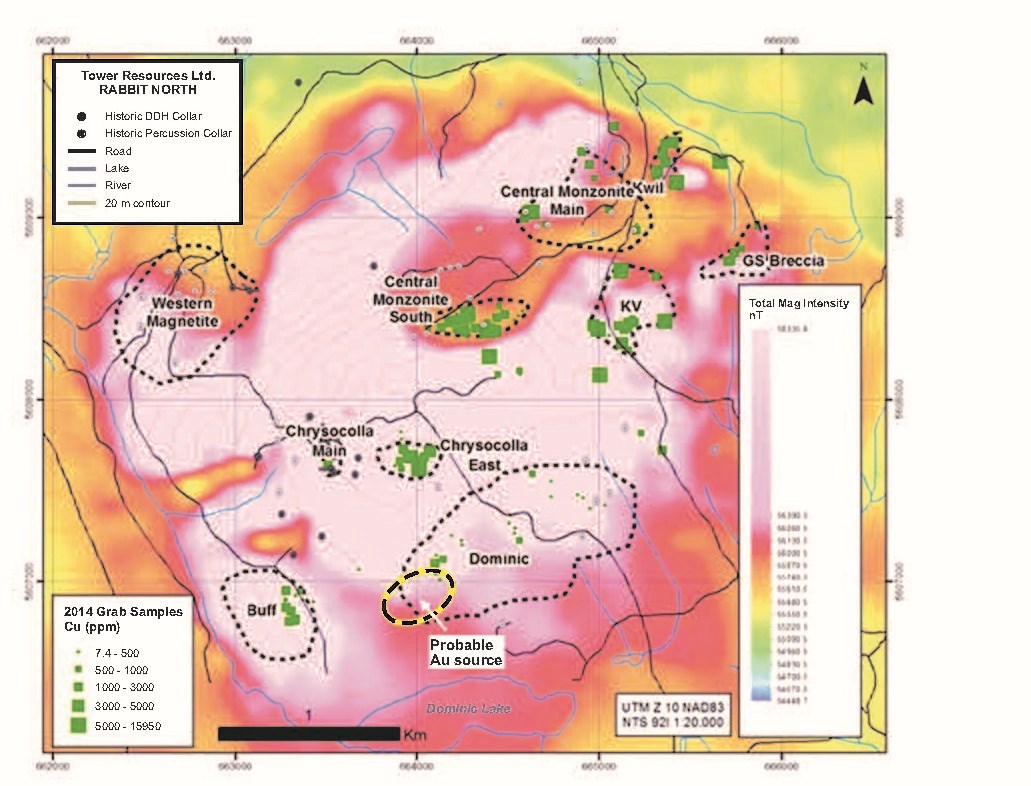
The potential for economic grades of both Cu and Au at Rabbit North is well illustrated by the deep Western Magnetite Zone (Fig. 4) that Tower discovered in 2016 by drilling in a thickly till-covered area at the west end of the Durand Stock. This zone yielded an impressive intersection of 247 m averaging 0.51% Cu and 0.34 g/t Au at a depth of 150-300 m (see Tower's July 11, 2017 press release). It was not detected in the till survey (Fig. 1) because the subcropping top of the zone — i.e. the part that was glaciated — is only weakly mineralized.
Despite its name, the Western Magnetite Zone actually has a low magnetic signature (Fig. 4) because the original magnetite and other Fe-bearing minerals in the volcanic host rocks have been sulphidized (hydrothermally altered) to non-magnetic pyrite and chalcopyrite. Interestingly, the prime new target area up-ice from anomalous Samples 058 and 059 is coincident with a similar magnetic low between the significantly magnetic Buff and Dominic showings.
Emerging Western Target
The overall Cu-Au fertility of the Durand Stock is reflected in the till by above-background levels of gold grains. Most samples immediately south of the stock, on the shoulders of the strong Samples 058/059 anomaly, yielded between 100 and 200 gold grains (Fig. 1). On the northernmost traverse on the up-ice margin of the stock, in contrast, the elevated values dissipate to a normal background of less than 25 gold grains per sample, indicating that the northern contact is infertile.
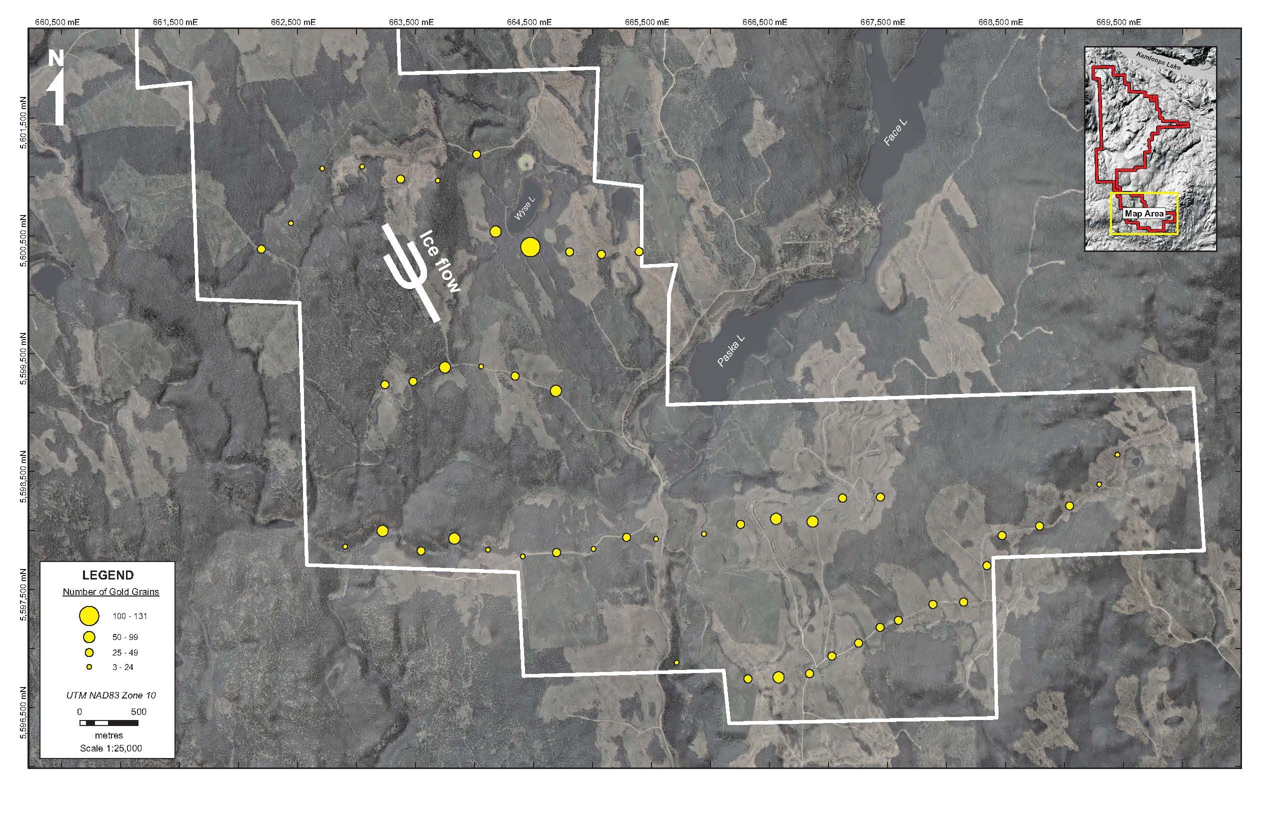
In the down-ice (southeast) direction, the fertility of the Durand Stock is evident in the till for at least 8 km, with many samples collected from the southern lobe of the property containing between 25 and 100 gold grains (Fig. 2). Importantly, only the eastern tip of this lobe of the property is directly down-ice from the stock. Similar to even higher levels of gold grains persist for 5 km to the west across the ice flow path, suggesting that the 5-km-wide area between the Durand Stock and the western property boundary (Fig. 1) is as prospective as the stock itself.
The indicated fertile area west of the stock is underlain mainly by volcanic rocks. It has not been explored previously because (a) the volcanics are separated from the stock by a late, northwest trending fault; and (b) they are largely concealed by till. However, the western fault block appears to be downthrown, suggesting that it has a high probability of containing satellite intrusions that were emplaced at a higher level than the stock and are potentially more prospective. Significantly, the highest-grade Cu-Au mineralization known on the property, in the Western Magnetite Zone (Fig. 4), is hosted by volcanic rocks rather than by the Durand Stock, and the geological setting of the presumed source of the Samples 058/059 gold grain anomaly (Figs. 1, 4) appears to be similar to that of the Western Magnetite Zone.
Next Steps
Follow-up till sampling is planned in the coming weeks to more accurately define the up-ice limit of the Samples 058/059 gold grain anomaly. It is expected that the till results will refine the gold source area sufficiently for an initial diamond drill test in September.
Till sampling will also be performed in the indicated fertile area west of the Durand Stock and over a small, essentially untested intrusion near the north end on the property.
Methods and Qualified Person
Overburden Drilling Management Ltd. (ODM) planned and executed the till survey and processed the samples at the company's heavy indicator mineral laboratory in Ottawa, Ontario. In advance of the survey, Stuart Averill, P.Geo., Chairman of ODM and a Director of Tower, scouted the property to confirm that till conditions were adequate for an effective survey. Mr. Averill also pre-selected the sample sites with the aid of stereo air photos.
ODM supplied a four-person field crew led by Donald Holmes, P.Geo. At each site, if till was evident, a pit was excavated into the C-horizon of the post-glacial soil profile, typically to a depth of 0.5-0.8 m, to reach minimally oxidized, structurally compact till, the subglacially deposited variety that is required for an effective survey. If this type of till was not present in the initial pit or exposed within 100 m, a gap was left in the survey. At every 20th site, a duplicate sample was collected for quality assurance purposes.
The till from each pit was sieved at 8 mm to obtain approximately 12 kg of -8 mm material which, when further screened in the laboratory, yields approximately 10 g -2 mm sandy silt, the particle size fraction that is normally processed for heavy indicator minerals.
Prior to extracting the heavy mineral fraction from the samples, ODM removed a representative 500 g split and further sieved it at 0.063 mm to separate the fine silt + clay fraction. This fraction is being analyzed geochemically in Ancaster, Ontario, by Actlabs Ltd., a laboratory certified as ISO/IEC 17025 Accredited (Lab 790) by the Standards Council of Canada. The samples are first digested in aqua regia, then analyzed by INA for Au and 34 other elements and by ICP/OES for a 10-element silver + base metal package that includes Cu and Mo. For every 30 survey samples, ODM included a blind (visually indistinguishable) quality assurance sample from a natural till section that contains consistently elevated levels of Au, Cu, Mo and other key elements.
Heavy mineral concentration was effected on the bulk of each sample using a shaking table modified by ODM to recover the fine, silt-sized gold particles that normally comprise 95% of the gold grains in till. The dimensions of each recovered gold grain were measured and the grain was classified as being still pristine, partially modified (physically deformed) or completely reshaped to gauge its relative distance of glacial transport.
The technical content of this news release has been reviewed and approved by Stuart Averill, P.Geo., a Director of the Company and a Qualified Person as defined by National Instrument 43-101.
About Tower Resources
Tower is a Canadian based mineral exploration company focused on the discovery and advancement of economic mineral projects in the Americas. The Company's key exploration assets, both in B.C., are the Nechako gold-silver project near Artemis' Blackwater project and the Rabbit North copper-gold porphyry project located between the New Afton and Highland Valley Copper mines.
On behalf of the Board of Directors
Tower Resources Ltd.
Joe Dhami, President and CEO
(778) 996-4730
www.towerresources.ca
Reader Advisory
This news release may contain statements which constitute "forward-looking information", including statements regarding the plans, intentions, beliefs and current expectations of the Company, its directors, or its officers with respect to the future business activities of the Company. The words "may", "would", "could", "will", "intend", "plan", "anticipate", "believe", "estimate", "expect" and similar expressions, as they relate to the Company, or its management, are intended to identify such forward-looking statements. Investors are cautioned that any such forward-looking statements are not guarantees of future business activities and involve risks and uncertainties, and that the Company's future business activities may differ materially from those in the forward-looking statements as a result of various factors, including, but not limited to, fluctuations in market prices, successes of the operations of the Company, continued availability of capital and financing and general economic, market or business conditions. There can be no assurances that such information will prove accurate and, therefore, readers are advised to rely on their own evaluation of such uncertainties. The Company does not assume any obligation to update any forward-looking information except as required under the applicable securities laws.
Neither TSX Venture Exchange nor its Regulation Services Provider (as that term is defined in policies of the TSX Venture Exchange) accepts responsibility for the adequacy or accuracy of this release.

Figure 1 - Gold grain abundance per 10 kg of till over and near the Durand Stock. Sample 060 is a duplicate of Sample 059 that was collected routinely as part of the quality assurance program. The area from which the transported gold grains in Samples 058 and 059 are probably sourced is also shown. The apparent strong anomaly in Sample 093 is inflated because the sample was collected directly over known mineralization.
To view an enhanced version of Figure 1, please visit:
https://orders.newsfilecorp.com/files/5023/92569_868960cd54ca796a_002full.jpg

Figure 2 - Gold grain abundance per 10 kg of till on the southern lobe of the Rabbit North property. The southeast direction of glacial ice flow and gold grain transport is visible from the grain of the topography. The east end of the survey area is 8 km down-ice from the Durand Stock. The generally higher gold content of the till in the central and western parts of the survey area suggest that the area west of the stock is more prospective than the stock itself.
To view an enhanced version of Figure 2, please visit:
https://orders.newsfilecorp.com/files/5023/92569_868960cd54ca796a_003full.jpg

Figure 3 - Gold grain abundance per 10 kg of till at the Mount Polley porphyry Cu-Au mine. The bedrock geology and till cover at Mount Polley are similar to those at Rabbit North and the till samples were collected and processed using the same protocols. Source: Plouffe et al. 2016.
To view an enhanced version of Figure 3, please visit:
https://orders.newsfilecorp.com/files/5023/92569_868960cd54ca796a_004full.jpg

Figure 4 - Known porphyry Cu-Au occurrences related to the Durand Stock. All but the Western Magnetite Zone, which lies at a depth of 150-300 m, are surface showings. The Western Magnetite Zone is actually coincident with a magnetic low produced by the hydrothermal alteration of the primary magnetite and other Fe-bearing minerals to pyrite and chalcopyrite. Note that the probable source area of the transported gold grains in till samples No. 058 and 059 is in a similar magnetic low between the magnetic Buff and Dominic showings.
To view an enhanced version of Figure 4, please visit:
https://orders.newsfilecorp.com/files/5023/92569_868960cd54ca796a_005full.jpg
To view the source version of this press release, please visit https://www.newsfilecorp.com/release/92569

